File:NASA Image of Barotse Floodplain.PNG

Original file (538 × 867 pixels, file size: 1.13 MB, MIME type: image/png)
| Description |
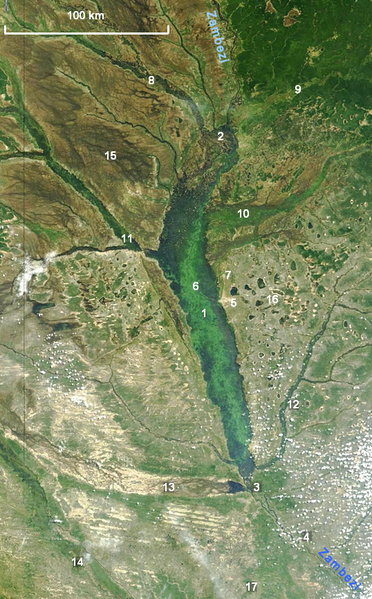
NASA satellite photograph showing the Barotse Floodplain as the bright green to dark blue central region. |
|---|---|
| Source |
"Seasonal Flooding in Southern Africa". NASA/Visible Earth, Credit: Jacques Descloitres, MODIS Rapid Response Team, NASA/GSFC. Labels added by User:Rexparry_sydney |
| Date |
2004-04-24 |
| Author |
Credit: Jacques Descloitres, MODIS Rapid Response Team, NASA/GSFC |
| Permission (Reusing this file) |
NASA general |
| Other versions | Image:NASA Barotse Floodplain compressed.JPG |
Key
1 The Zambezi flowing north to south through the middle of the floodplain; 2 confluence of (left to right) the Lungwebungu, Southern Kashiji, Zambezi and Kabompo Rivers, marking the start of the floodplain; 3 end of the floodplain south of Senanga; 4 Ngonye Falls on the Zambezi; 5 Mongu, capital of Barotseland; 6 Lealui, seat of the Litunga on the floodplain; 7 Limulunga, seat of the Litunga during the flood; 8 swamps and floodplain of the Lungwebungu; 9 the Kabompo drains an area of Cryptosepalum dry forest; 10 Luena Flats (floodplain); 11 Luanginga River floodplain near Kalabo; 12 Lui River with narrow floodplain; 13 a broad floodplain which carries overspill from high floods of the Cuando River in Angola; 14 Cuando river and floodplain, on the border between Angola and Zambia; 15 Liuwa Plain National Park; 16 The flat sandy Miombo woodland west of Mongu features many pans; 17 Sioma Ngwezi National Park.
File history
Click on a date/time to view the file as it appeared at that time.
| Date/Time | Thumbnail | Dimensions | User | Comment | |
|---|---|---|---|---|---|
| current | 15:13, 6 July 2016 | | 538 × 867 (1.13 MB) | Chalochatu (talk | contribs) | {{Information |Description=NASA satellite photograph showing the Barotse Floodplain as the bright green to dark blue central region. |Source=[http://visibleearth.nasa.gov/view_rec.php?id=6926 "Seasonal Flooding in Southern Africa".] ''NASA/Visible Eart... |
You cannot overwrite this file.
File usage
The following file is a duplicate of this file (more details):
- File:NASA Image of Barotse Floodplain.PNG from Wikimedia Commons
The following 4 pages use this file: