File:Chinsali town district location.PNG
From Chalo Chatu, Zambia online encyclopedia

Size of this preview: 800 × 547 pixels. Other resolutions: 320 × 219 pixels | 640 × 438 pixels | 905 × 619 pixels.
Original file (905 × 619 pixels, file size: 137 KB, MIME type: image/png)
Summary
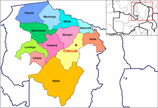
| Description | Chinsali town & district location map |
| Date | |
| Source | self-made from Image:Northern Zambia districts.png by User:Rarelibra (public domain) |
| Author | revisions by MyName (Rexparry sydney) |
| Other versions | similar to Image:Northern Zambia districts.png |
Licensing
| I, the copyright holder of this work, release this work into the public domain. This applies worldwide. In some countries this may not be legally possible; if so: I grant anyone the right to use this work for any purpose, without any conditions, unless such conditions are required by law. |
File history
Click on a date/time to view the file as it appeared at that time.
| Date/Time | Thumbnail | Dimensions | User | Comment | |
|---|---|---|---|---|---|
| current | 13:53, 20 April 2007 | | 905 × 619 (137 KB) | wikimediacommons>Rexparry sydney~commonswiki | {{Information |Description=Chinsali town & district location map |Source=self-made from Image:Northern Zambia districts.png (public domain) |Date=20-4-07 |Author= MyName (~~~) |other_versions=Based on Image:Northern Zambia districts.png }} |
File usage
The following page uses this file: