File:ISS009-E-7622- Zambezi river near Mongu.jpg
From Chalo Chatu, Zambia online encyclopedia

Size of this preview: 800 × 527 pixels. Other resolutions: 320 × 211 pixels | 640 × 422 pixels | 1,024 × 675 pixels | 1,280 × 843 pixels | 3,032 × 1,998 pixels.
Original file (3,032 × 1,998 pixels, file size: 4.71 MB, MIME type: image/jpeg)
Summary
| Description |
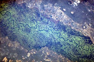
English: The Zambezi river and its floodplain, seen from the international space station. |
| Date | Taken on 16 May 2004, 14:23:54 UTC |
| Source | http://eol.jsc.nasa.gov/scripts/sseop/photo.pl?mission=ISS009&roll=E&frame=7622 + Own work |
| Author | NASA |
| Camera location | | View this and other nearby images on: OpenStreetMap |
|---|
This image or video was catalogued by Johnson Space Center of the United States National Aeronautics and Space Administration (NASA) under Photo ID: ISS009-E-07622. This tag does not indicate the copyright status of the attached work. A normal copyright tag is still required. See Commons:Licensing. Other languages:
|
Licensing
This file is in the public domain in the United States because it was created by the Image Science & Analysis Laboratory, of the NASA Johnson Space Center. NASA copyright policy states that "NASA material is not protected by copyright unless noted". (NASA media use guidelines or Conditions of Use of Astronaut Photographs).
Photo source: ISS009-E-07622.
|
Original upload log
Transferred from en.wikipedia to Commons using FtCG.
The original description page was here. All following user names refer to en.wikipedia.
| Date/Time | Dimensions | User | Comment |
|---|---|---|---|
| 09:28, 1 June 2010 | 3,032 × 1,998 (4,934,566 bytes) | w:en:Originalwana (talk | contribs) | (higher res, changed white balance ) |
| 10:50, 10 August 2005 | 639 × 435 (37,968 bytes) | w:en:Worldtraveller (talk | contribs) | (The Zambezi river and its floodplain, seen from the international space station. From http://eol.jsc.nasa.gov {{PD-USGov-NASA}}) |
File history
Click on a date/time to view the file as it appeared at that time.
| Date/Time | Thumbnail | Dimensions | User | Comment | |
|---|---|---|---|---|---|
| current | 06:26, 27 February 2012 | | 3,032 × 1,998 (4.71 MB) | wikimediacommons>Bulwersator | Transferred from en.wikipedia: see original upload log above |
File usage
The following page uses this file: